Kathmandu valley offers many popular hikes and among those Suryabinayak to Lakuri Bhanjyang hike is one of the popular ones. These hikes offer solace from all the hustle-bustle of the Kathmandu city and refresh one’s mind. This is sort of cityscape from all the hustle-bustle. As the hike goes past the beautiful Ranikot Village that commands the majestic mountain panorama during the clear days. It takes about 3hrs to hike from Suryabinayak to Ranikot. Another additional 1 hour is added for ascending towards the Lakuri Bhanjyang. It’s a small hilltop near the Kathmandu Valley that provides a splendid view of the valley with the wonderful; views of Himalayas. The route or trail towards this fantastic place is just less crowded and very scenic. One can enjoy the beautiful views of the countryside, terraces and the day to day life of the locals inhabiting the area.
Why Lakuri Bhanjyang Hiking?
Explore the new hiking route in Kathmandu.
Be away from the hustle-bustle of Kathmandu.
Experience rural life.
Enjoy the great view of the Himalayas.
Route:
Take a bus towards Suryabinayak from Kathmandu
Walk from Suryabinayak Bus Station to Surbinayak Temple (Approx 20-30 minutes)
From temple take the right turn and head towards the Army Barrack (Approx. 20 minutes)
Follow the trail until reaching Tarkeshowr Mahadev Temple (Approx. 30 minutes)
From Temple climb the Hill towards Pilot Baba Ashram (Approx. 45 minutes)
Then head the trail towards Ranikot (Approx. 45 minutes)
From Ranikot take a right turn and follow the trail towards Lakuri Bhanjyang (Approx. 1 hour)
And then finally descend down towards the Lamatar (Approx 1.5 hr)
Take a bus that goes to Lagankhel
Mother Nature is just BeautifulNearing the top of LakuriInto the wild
As the world’s highest mountain sits upon the Mahalangur section of the Himalayas, the mountain’s summit straddles the border separating China and Nepal. Reaching 298,029 feet(8,848 meters) above sea level, one can assume to be the king of the mountains and overcoming the king has always been the holy grail of mountaineers. Every year, people from all over the world visit Nepal just to soak in the beauty of this magnificent construct of nature. As the Everest attracts experienced mountaineers as well as less-seasoned climbers and has been on the list of every climber either they be professional or seasonal. And the most popular among all the treks is the one to Everest Base Camp.
Everest Base Camp(EBC)
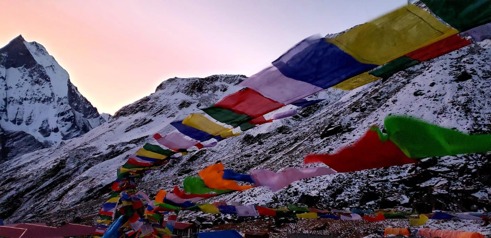
Everest Base Camp Trek is one of the most searched and preferred trekking destinations by the trekkers around the world and this trekking could be a combo of both adventure and challenge for you. Everest base camp trek will walk you downhill through the forest of rhododendron, magnolia, and pine. Ahead lie small settlements and flat trails with pleasant alpine vegetation, monasteries, colorful prayer flags and so does the valley, which is so beautiful that you are bound to click your camera. Another beauty is the Dudh Kosi River, a glaciated river, which is as white as milk and which you cross often by the high suspension bridges that will make the trek livelier.
How to get to the Base Camp?
Primarily most of the trekkers take a flight from Kathmandu to Lukla to reach EBC but due to the rehabilitation work being carried out and domestic and international flights being disrupted the Civil Aviation Authority of Nepal has notified the airlines to reroute the flight to Lukla from Manthali Airport of Ramechhap.
Another way of reaching EBC is through a highway drive to Jiri/ Salleri heading toward the off-beaten trail taking you to the Salleri for Everest Trek. This is for those who enjoy slow travel and the bonus for slow traveling is until you get to Lukla, are less crowded, have spectacular views, and wonderful insights into the Solu Sherpa culture.
Minimum and Maximum Time frame of the Trek?
Well, this generally depends upon the trekker preference if the trekkers are physically fit and can manage a 7-9 hours trek daily up the mountains then he/she can normally complete the trek in 10 days. But this journey is very strenuous as it takes a 16 days trek(Max) and compacts it for a shorter trek which eventually hikes up the trekking hours per day. So, if you are someone who hasn’t had much experience of trekking and wants to trek enjoying each and every moment at the region then a 14 days time frame would be appropriate as it gives you the proper time to acclimatize and enjoy the scenic beauties of the trek.
Budget Required For Everest Trek
Well, the budget estimation depends on what kind of trek one is embarking on and how much of a spender one is. But generally, the cost ranges from anywhere around US $900 to US $1800. It depends on how much one would like to splurge oneself with various extra luxuries as well.
Necessary Permits Required
Update: Oct 1st 2018 TIMS Card is no longer valid for Everest Base Camp Trek
With decentralization, a new permit system has been implemented on Everest Region. You will no longer require a Trekker’s Information Management System (TIMS) Card. With lots of controversy and dispute, this new local entry permit has completely replaced the old trek permit in Khumbu.
The necessary permits required for trekking to EBC are :
You just need your passport details for Khumbu Pasang Lhamu Rural Municipality and Sagarmatha National Park Entrance Permit. You will need two photos for the Gaurishankar Conservation Area Project Entry Permit and you also need to fill up a short form to obtain the permit. All these fees are payable in local currency only.
How is Everest Base Camp on each Season?
Although it is possible to trek on Everest throughout the year on any given seasons but the best time to visit Mount Everest is in the Spring and Autumn. As during the autumn season, the weather tends to be relatively stable with mild to warm days and cold nights. And during Spring the weather is quite clear and the peaks are often visible and the temperature is warm and just ideal for a trek.
Spring Season(April-May):
The spring months are probably the most popular in the region as a whole. You might be caught in the occasional snow showers if you catch the end of the winter season, but the weather should be largely stable and dry- perfect for trekking and high altitude climbing.
Autumn Season(September-November):
Clear days are characteristic of this popular trekking period. Although colder days(and colder nights) are to be expected, this is a small price to pay for the wonderful vistas and perfect views of the region peaks. And added bonus of trekking during this time is the option to choose some other, less well-known routes in the area that still offer amazing views but without the hustle and bustle of the more popular routes.
Winter Season(Dec-Feb):
The region during this period can best be described as being very cold but still is trekkable. The days will be shorter and there is a lot more snow, thus routes that involve crossing big passes like the three passes trek are usually closed. The weather will be fairly stable and dry, meaning it is entirely possible to trek the classic route to Everest Base Camp in these months. 0One can expect the temperature to be as cold as -30degree Celsius at night higher up the route.
Summer Season/Monsoon Season(June-August):
Summer may sound like the prime time to visit Mount Everest, but it is also monsoon season during which the mountain can receive large amounts of rainfall. During the monsoon season, the Everest peak is, more often than not, shrouded in mist. Although a trek is doable during this season, it is quite difficult as the slippery trails, leeches and the lack of mountain views are just about enough reasons in off-putting most trekkers from trekking.
Everest Base Camp Trek Difficulty
The trek to Everest Base Camp is approximately 130km, so you need to walk 15km per day for about two weeks. It’s not a plain walking surface and like most typical treks in Nepal, there’s a lot of going up and down. The distance you cover does not require super fitness, the altitude does, however, make it tough. And also having a strong mindset is also very important while trekking in these parts of the mountains. Everest Base Camp Trek is influenced by; your pack weight, a porter can make it much easier and season, if you’re cold and miserable then it is definitely harder.
To sum it up you will be walking 5 to 8 hours a day for 16 days, with a resting day or two for acclimatization. If you are reasonably fit you should be able to do this to carry your own backpack.
Tipping Guide/Porter
In Nepal tipping is not mandatory but it is expected as major earning or saving funds is the tips for the guide/porter. Tipping is based on the experience you had with your trekking team. It totally depends upon how you felt about the services and overall hospitality that was provided to you so if you are satisfied you can tip them accordingly.
Is Internet/Electricity Available in the Everest Base Camp Region?
One can buy internet as there is a service called Everest Link through which one can get certain data package for a certain amount of money and after the purchase of the data pack one can get access to the internet in most parts of the region. But be warned that the signal often goes down and you will lose signal depending on where you are on the trail. As the elevation also factors in good signal strength of the mobile and internet signals.
As for electricity for charging electrical devices, there is proper electricity in Lukla, Phakding, Namche, and Tengboche. You can charge your batteries with solar devices in Pheriche, Labuche and Gorakshep. However, it is better to charge as much as possible till Tengboche and have enough back up for further up as charging facilities depends upon weather higher up.
Some Hotel facilitates charging in the room itself without extra cost. While in other they charge 300 to 400 per battery per hour.
Necessity of Insurance:
While traveling to Nepal, you are requested to have travel insurance that should cover any comprehensive expenses possible to acquire due to medical issues or accidents. Especially, your travel insurance must protect air ambulance, treatment charges, rescue and evacuation, product cancellation and refundable charges, flight delays, and cancellations.
Insurance Policy:
Traveling in the Himalayas is full of adventurous; hence it is wise to choose a proper insurance policy. While choosing your insurance policy, make sure that it will protect all such unforeseen expenses. You must ensure that the policy you do take provides an adequate level of protection, well familiar with your itinerary and covers you for the activities involved. You must carry proof of insurance (e.g. your insurance certificate) with you on holiday or send us a scanned copy and it must be issued from your homeland.
Preventing Altitude Sickness
Altitude sickness is caused by ascending too quickly. It is wise to climb slower to prevent it. As, it is very common on the Everest Base Camp trek and can happen to anybody, irrespective of how old or fit you are or if you have previous trekking experience. So, here are some ways to prevent Altitude Sickness:
Hydration– Drink plenty of water, it’s very important to stay hydrated.
Trekking Pace– Walk at your own pace, take your time, don’t go too fast.
Eat carbs– It’s not often we’re told to eat extra carbohydrates but when you’re at higher altitudes, you need more calories.
Avoid Alcohol– Alcohol, cigarettes, and medications like sleeping pills can make altitude sickness symptoms worse. So, avoid it.
Medication– Taking acetazolamide(Diamox)two days before the trip and during your trip can help prevent altitude sickness. Acetazolamide is a medication typically used to treat glaucoma. But is also used to prevent altitude sickness.
Alternatives to EBC Treks?
Apart from EBC trek, there are other plenty of trekking options that one might like to consider as the Everest region is itself is a very beautiful and adventurous place. Here are some few of the best trekking alternatives apart from EBC.
High Passes Trek
Crossing Three High Himalayan Passes
Incredible Exploration of Gokyo Region
Breathtaking Himalayan View
Everest Base Camp and Kala Patthar Trekking
Island Peak
Wonderful View of The Mt. Everest
Cultural Wonders of Everest Region
Tengboche and Pangboche Monasteries Exploration
Peaceful yet adventurous walk all throughout the trip
Gokyo Valley
Trek to Gokyo Lakes and Gokyo RI
Visiting All of the high valleys of the Khumbu with extra time
Soaring views of the most popular mountains in Nepal
Cultural Wonders of Everest Region
Truly Beautiful View of the EverestThe Mighty Everest
So, if the above-mentioned things are taken into proper consideration than you will have a wonderful time trekking in the most spectacular region. Carry all the necessary permits as mentioned above take all the precautions and there’s no way you are not going to have a wonderful time.
Living Goddess kumari being escorted around the city streets during the celebration of Indra Jatra.
The most enthralling and loved festival of the Newar community in the Kathmandu Valley falls in the month of September which is celebrated for eight days.
“As the name suggests Indra Jatra being the festival of the rain god and also the king of heaven. It is also believed to be the day for thanking the Lord Indra for the rain.”
The festival takes off every year from the day of the Bhadra Dwadasi to Ashwin Krishna Chaturdasi. It begins with the erection of a wooden(Linga) pole made of pine at Basantapur Square in front of the Old Hanuman Dhoka Palace. The very first day of the festival is also noted by the Newars as a day to remember the family members who passed away during the past year by offering small oil lamps placed along a traditional route canvasing all the parts of the old city. It is presumed to have been commenced during the reign of Mahendra Malla. Accompanied by the rare display of the deity Akash Bhairav, represented by a massive mask spouting Jaad and Raksi(Nepali Local Liquor). Kumari, the Living Goddess, along with Ganesh and Bhairav is taken out in a procession through the main streets of Kathmandu in their chariots. Masked Dancers, known as Lakhay also take to the streets almost every evening accompanied by loud drums. And also with the Lakhay, a wooden construct of the Lords Elephant takes to the street known as Pulunkisi or Tana-kisi. Each night on the platform of the temple of the Living Goddess, there is an enactment depicting the ten early incarnations of Lord Vishnu. Besides these, various dances are held on the open stages of the city called dabu. There is a display of Swet Bhairava as well as various deities of the city.
The procession consists of:
Majipa Lakhey
Pulukishi
Sawan Bhaku
Ganesh (Chariot)
Kumar (Chariot)
Kumari (Chariot)
The story behind the Jatra:
Indra’s mother needed parijat, a type of flower, for some religious ritual so Indra disguised as a human being came to the earth to fetch them. But, he was immediately identified when he was to steal the flowers so the people caught him and tied him with ropes. As the statue of the great deity himself is still worshipped in Maru Tole in Kathmandu. This image is also put on display with others in different parts of the city during the Indra Jatra festival.
Indra Jatra being an interesting festival is celebrated for the whole week as people enjoy various traditional dances and witness the chariot of Goddess Kumari, Lord Ganesh and Lord Bhairav being pulled through the older parts of the Kathmandu city. A day has been added to the original seven days of celebration and on that day known as Nanicha yaa, the chariots are pulled through Naradevi, Nhyokha, Ason, Indrachwok and Hanuman Dhoka. This extra day of chariot pulling was introduced by King Jaya Prakash Malla in 1765 B.S.
The famous Akash Bhairava bust is displayed and it is decorated with flowers in the valleys most famous Indra Chwok. This Akash Bhairava’s head is related to the Mahabharata story. Some believe it to be the head of the first Kirat King Yalamber. In Indra Chowk, every night different groups gather and sing bhajans and hymns.
One most important activity of the Indrajatra is to offer wick lamps on clay dishes in the name of family members who died in a year, on the way to going around the town of that time. This is called Upaku-wonegu. People observe this tradition even today. Therefore, some people believe that the main purpose of celebrating Indrajatra at the time of Licchavi was to make special offerings to the souls of deceased loved ones before observing a big festival called Dasain.
During Indra Jatra, there are a variety of performances including the dances of Sawa Bhakku Bhairav from Halchowk, Majipa Lakhey from Majipat, Devi Nach and Yeravat Hatti (Pulukisi) from Naradevi, Mahakali and Kathi Maka Nach from Bhaktapur. All the dances take place around the Hanuman Dhoka area. The Dasavatar or the ten incarnations of Lord Vishnu is also staged every night.
A legend has it that the first Malla king brought with him the Goddess “Taleju” – a Hindu Goddess. The Malla kings used to have direct talks with the Goddess “Taleju”. Due to the misdeed of one of the Malla kings, the Goddess refused to have one-on-one talks with the king. However, several years of penance, the Malla king succeeded to persuade the Goddess to appear in person. The Goddess agreed to appear as the Living Goddess Kumari. So, both “Taleju” and “Kumari” are the same Goddess, only a different name for a different faith.
The Linga (Yasingh) is pulled down signaling the end of the Indra Jatra festival. It is taken to the confluence of Bagmati and Bishnumati in Teku to be put to rest.
The end of the Indra Jatra festival heralds the beginning of Dashain and Tihar celebrated with great enthusiasm not only in the Kathmandu Valley but throughout the country.
The statue of Swet Bhairav as people are struggling to dink homemade alcohol poured out from the mouth of the idol as a blessing.
Mt. Kanchenjunga is the third highest in the world at 8,598m, it sits spanning the Nepal/Sikkim border only a few miles from Tibet, the name Kanchenjunga means ‘five great treasures of snow’ i.e. Silver, Gold, Precious Stones, Grain, and Holy Scriptures, which hints at the spectacular mountain views that await. This route was opened to trekkers in 1988, though people have trekked in the area in connection with mountaineering expeditions since the turn of the century. Mt. Kanchenjunga is the third highest mountain in the world at 8,596m it sits across the Nepal/Sikkim border and is only a few miles from Tibet. This trek offers magnificent views of Everest, Makalu, and Kanchenjunga.
The trail climbs from the intensively cultivated hillsides of the Nepal Midlands, populated by the Rai and Limbu tribes. This trek will take you through gorgeous Rhododendron forests and picturesque villages. You will see a collection of wildlife and trek over high mountain passes offering mind-blowing views. On completion of this outstanding trek, undoubtedly you will be left with a bundle of wonderful memories.
Kanchenjunga Base Camp Weather
Since the route of Kanchenjunga Base Camp Trek goes across the diverse climate zones, it is a bit difficult to predict weather conditions in this trail. The lowest altitude of this trekking route is at Taplejung which is at the altitude of 1820 m above sea level. And the Kanchenjunga Base Camp, our destination of this trek stands tall at an altitude of 5140 m above sea level. This causes a drastic change in temperature.
There is no uniform weather conditions at different altitudes even in the same season. Climate and weather vary in different altitudes but you can somehow figure out the pattern of climatic conditions in different altitudes in different seasons.
Winter Season(Dec-Feb)
November, December, January, and February winter in Nepal. Early winter is one of the best times to trek Kanchenjunga Base Camp other than Autumn. It is quite cold at high altitudes but the views of the landscape are crystal clear in this period of time. The lodges will be closed in this season in Pangpema and Ramche. So, you will have to camp at these rest stops. The temperature may drop to minus 30 degrees or more. That’s why, you must be prepared with all the winter gear, equipment, and clothes that will protect you from the cold. In late winter, the temperature begins to rise. The heavy snow deposits start to meltdown and flowers start to bloom everywhere at the lower altitudes.
Autumn Season(Sep-Nov)
The perfect season to trek in Kanchenjunga Base Camp or any other place in Nepal is in the autumn season. The weather in the trekking route will be perfect with not much wind or clouds. It will neither be too hot nor too cold. Autumn is also the time of the year when a lot of festivities take place. You could score some special local delicacies too. Taking part in the local culture and festival is an experience not to be missed.
Summer Season/Monsoon Season(June-August)
June, July, and August are the months of summer in Nepal known as monsoon or rainy season. It is super-hot in the lower regions at this time of the year, especially in the eastern regions of the Terai and Hilly regions of Nepal. The month of June is the pre-monsoon period and the temperature decreases during the downpours and rises on sunny days. Clouds will most likely cover the majestic views of mountains and different landscapes. But when the clouds clear up, you will be stunned by the view. Trekking in monsoon in Nepal can be a unique adventure in itself. If one is willing to go for trekking in the Kanchenjunga region, one is strongly recommended to do so. Just be sure to take precautions and safety measures.
Spring Season(March-May)
The month of March brings spring in Nepal and continues up until May. In the early spring, the weather is close to perfect and temperatures at high altitudes are still cold but not as cold as in winter. The weather in the lower regions of the trekking trails is also perfect. The tea houses and lodges start to open in the alpine zone that was closed during winter due to heavy snowfall and freezing temperatures. You don’t need to have all your camping gear while trekking in this season. You can easily cross the Sele La pass without difficulties. Late spring provides the blooming of colorful flowers in the entire lush green forest. Green hills and the white snow-capped mountain views are incredibly stunning. Very few traces of clouds can be seen in the sky.
Kanchenjunga Trek Equipments Checklist
Lots of people trekking in the Kanchenjunga area are on their first high alpine trek. In order to help those with less experience in choosing suitable equipment for trekking in high alpine areas we have listed a summary below. If trekking in Kanchenjunga is going to be your once in a lifetime experience, then there is no need to purchase expensive items of equipment. A lot of expeditions leave their equipment in Nepal and there are several shops in Kathmandu that will sell or rent you almost any piece of equipment that you would need.
Duffle bag/Rucksack
Day backpack
Down jacket
Sleeping bag
Head accessories(sun hat, sunscreen, warm fleece hat)
Lower Body(hiking shorts, fleece or thermal pants, waterproof shell pants, undergarments, and lightweight inner thermals, lightweight hiking pants)
Toiletries(toilet paper, toothbrush, and paste, small towel, soaps, nail scissors)
Personal Hygiene(wet wipes, normal dry tissue, handwash)
General Accessories(Headlamp, small combination for a backpack, first aid kit, bottles, trekking poles)
Extra(iPad,tablets,indoor games,guidebook and map, binoculars)
Kanchenjunga Base Camp Itinerary Details
Kanchenjunga is the third highest mountain in the world is situated in the eastern region of Nepal Border. It is engulfed with mesmerizing natural beauty and authentic Buddhist culture and still, it remains off the beaten trek in Nepal. Only about 2,000 tourist hikes Kanchenjunga compared to 30,000 tourists hiking in Everest Base Camp every year.
The trekking region of Kanchenjunga is filled with rhododendron and bamboo forests and offers a panoramic view of mountains and is home to some of the ethnic communities of Nepal, such as Rais and Limbus and its trekking trail is off the beaten in nature. Trekking in this region means doing one of the longest treks in Nepal, as well as walking in the far northeastern region in Nepal.
The main highlights of the Kanchenjunga region trek are Kanchenjunga South Base Camp, Kanchenjunga North Base Camp, Yalung Glacier, and an altitude of 5,143 m, alpine forest, and quaint villages, Pangpema, including a panoramic view of Kanchenjunga and neighboring peaks.
Below we have given the 24 days of a summarized itinerary for your Kanchenjunga Base Camp Trek from your arrival in Kathmandu until your departure day. The following itinerary guides you to the base camp from the Northside and also covering the Southside as well. This route is easier and preferred route to the base camp.
Outline Itinerary
Day 01: Arrival in Kathmandu and transfer to the hotel.
Day 02: Drive to Suketar(Drive: 28 hrs)
Day 03: Suketar to Mitlung(Trek: 7/8hrs, Altitude: 921 meters)
Day 04: Mitlung to Chhiruwa(Trek: 6/7hrs, Altitude: 1270 meters)
Day 05: Chhiruwa to Lelep(Trek: 5/6hrs, Altitude: 1940 meters)
Day 06: Lelep to Amjilosa(Trek: 5/6hrs, Altitude: 2510 meters)
Day 07: Amjilosa to Ghunsa(Trek: 6/7hrs, Altitude: 3595 meters)
Day 08: Acclimatize Day in Ghunsa
Day 09: Ghunsa to Khangpachhen( Trek: 4/5hrs, Altitude: 4100meters)
Day 10: Khangpachhen to Lhonak(Trek: 4/5hrs, Altitude: 4785 meters)
Day 11: Lhonak to Kanchenjunga Base Camp/ Return to Lhonak( Trek: 6/7hrs, Altitude: 5143 meters)
Day 12: Lhonak to Khangpachhen
Day 13: Khangpachhen to Ghunsa
Day 14: Ghunsa to Lumba Samba (Trek: 4/5hrs, Altitude: 4206 meters)
Day 15: Lumba Samba via Sele La Pass to Ramche(Trek: 7/8hrs, Altitude: 4580 meters)
Day 16: Ramche to Yalung Base Camp (South Side)/Return to Ramche(Trek: 6/7hrs, Altitude: 4500 meters)
Day 17: Ramche to Anda Phedi(Trek: 4/5hrs, Altitude: 3370 meters)
Day 18: Anda Phedi to Yamphudin( Trek: 4/5hrs, Altitude: 2080 meters)
Day 19: Yamphudin to Mamankhe or Phumphe Danda(Trek: 4/5hrs, Altitude: 1785/1858 meters)
Day 20: Phumphe danda or Mamankhe to Kade Bhanjyang(Trek: 4/5hrs, Altitude: 2129 meters)
Day 21: Kade Bhanjyang to Illam(Drive: 4/5hrs)
Day 22: Illam to Bhadrapur(Drive: 2hrs)
Day 23: Fly back to Kathmandu(Flight: 1/2hrs)
Day 24: Departure day
Kanchenjunga Trek Difficulty
You don’t have to be an experienced mountaineer or trekker to finish the Kanchenjunga Base Camp Trek. On the other hand, it doesn’t mean that Kanchenjunga trek is as simple as walking or running in a park. An adequate level of physical fitness and training needs to be done if one really wishes to complete Kanchenjunga Trek smoothly. From our previous experiences with clients let us break down some of the basic training you can do at home or at the park nearby as part of the preparation.
Running in the park: At least one month before the date of departure a minimum of 5-8 km a day. It will dramatically help breathing and blood circulation in addition to building up your thigh and torso muscles.
Swimming: Holding your breath and swimming helps to store oxygen that will ease short breathing in the high altitude.
Yoga or Aerobic: Give some time doing yoga, stretching your body, jogging to tone up your body and muscles, etc.
Gym: If you plan hiking with a loaded backpack, we suggest extra exercise, especially leg Squat, Leg press, Deadlift, Leg extension, Wall sits, Leg curl, etc.
So, with proper training and preparation, one can challenge oneself on this once in a lifetime trek to the less touristic region where exploration of the villages and Himalayan culture of primitive Rai, Limbu and Sherpa communities and also the wilderness is a true joy. And also one can immerse oneself in the rich flora and fauna of the region which will leave anyone speechless. With the right preparation, the journey to the Kanchenjunga Base Camp will be a memorable adventure that one cannot miss.
Pikey is situated at the Lower region of Solukhumbu district at an altitude of 4070 m. From Pikey peak, one can get the grand view of nature, can experience the traditional livings of different ethnic groups like Sherpa, Chhetri, Tamang, and Gurung. Tourists can taste the verities of local cuisines and observe some rare plants and animals. Tourists can observe the best view of the highest peak of the world Mt. Everest in the short trek. From Pikey peak, one can get the grand view of mountain peaks like Dhaulagiri, Everest, Makalu, Kanchenjunga, AmaDamlam, Lhotse, Nuptse, Number, Gaurisankhar, Langtang to the far west. Additionally, Pikey peak rewards tourists with one of the best sunrises and sunset views. It offers dense forests of Sunpati, Pine, Rhododendron whereas attraction of birds and animals like Lophophorus, Crimson Horned Pheasant, tiger, wild bear, Panda, Ghoral and so on. Similarly, Chauri Ghai, Nak, yak, and cow can be found anywhere in this area.
Tourists can have a pleasing view of nature’s unique scenes, villages and living way of Sherpa, Tamang, Chhetri, Gurung, and Sunmuwar. To reach Pikey peak, bus or jeep ride from Bamtibhandar of Ramhechap district -the Okhaldhunga dhap-Khinji Phalate -Salleri of Solukhumbu district and then trek can be followed. Other alternative can be a flight to Paplu airport of Solukhumbu district. The villages belonging to Likhu Pikey rural municipality include villages like Chaulakharka, Gole. Similarly, other villages of Solududhkunda municipality like Kerung, Tapting, Tamakhani, Gorakhani, Salleri, and Junbesi also lie at Likhu Pikey rural municipality. Likewise, other villages of Okaldunga district and Ramechhap district such as Patale, Kiji Demba and Bamtibhandar are also the part of Likhu Pikey Peak Trek.
Highlights of Pikey Peak Trek
Duration: 10 Days
Type of Trek: Camping/Tea House
Activities: Trekking, Culture Tours
Max Altitude: 4070m.
Mode of travel: Land Transportation
Best Month: September/October/November/ March/April/May
OUTLINE ITINERARY:
Day 01: Arrive Kathmandu Day 02: Drive from Kathmandu to Bamti Bhandar – Altitude: 2990 m Day 03: Bhandar – Namkheli Day 04: Namkheli – Golla Day 05: Golla – Pikey Base Camp Day 06: Pikey Base Camp – Pikey Peak – Junbesi Day 07: Junbesi –Thupten Chholing Day 08: Junbesi – Chiwang-Phaplu Day 09: Phaplu – Kathmandu Day 10: Depart Kathmandu
Tamang Heritage Trek is an attempts to explore the Traditional Tamang in the lap of Ganesh Himal and Langtang range closer to Tibetan vicinity.
Tamang Heritage trek offer a rich culture and tradition of Tamang, beautiful Mountains and adventurous trekking experience. Entering to the Tamang hamlets let you experience the isolated lifestyle rituals, festivals, Tibetan culture, unique architecture, costumes and the local Syabru dance with background of charming mountains. Explore the ancient Gompas, Buddhist prayer rocks engraved with sacred mantras and colorful prayer flags that mystify the Himalayan habitat of Tamang.
Tamang is an ethnic group hugely settled in lap of Langtang range, considered to be migrated from Burma via Tibet during 7th/8th centuries. Etymologically, Tamang originates from two words in Tibetan language: “Ta” means Horse and “Mang” means Warrior. The warm hospitality of Briddim and joining with the host family, savoring local cuisine will make your trip awesome.
Tamang Heritage Trail Trek Itinerary
Day 01 Arrival day in Kathmandu (Altitude: 1350/4428 ft. Meal: Dinner) On your arrival in Kathmandu International Airport, one of our representative will pick up you and escort you to the hotel as well as help you to check-in at hotel. After your refreshment, you will be briefed about the next day trip. In the evening, we, the Treks Planner Nepal will offer you a welcome dinner introducing Nepalese cuisine and culture.
Day 02 Cultural Tour of Kathmandu City UNESCO Heritage Sites (Altitude: 1350/4428 ft. Meal: Breakfast) After your delightful breakfast, you will be introduced with guide and takes you to UNESCO Heritages sites of the valley where you will observe living heritage of Medieval Nepal – Witness the biggest Hindu temple of Nepal, Pashupatinath and capture the sacred moments of Hindu death ritual at Aryaghat in Pashupatinath. Stroll the lively streets of Kathmandu Old Market Asan to Kathmandu Durbar Square and visit the home of The Living Goddess Kumari, Nepalese style of Architecture as well as astonishing wooden carving. A short drive from Kathmandu Durbar Square will take you to a hill top stupa called as “Swyambhu” meaning “self -emerge” and belief that the hill emerged impulsively from the great lake that once covered Kathmandu valley. Also famous as a Monkey Temple.
Day 03 Drive to Syabrubesi (Altitude: 1,420m/4,658ft Drive: 8/9 hrs. Meal: BLD) After Breakfast, re-check your baggage and get ready for a long drive to Syabrubesi. Taking a turning to the northern highway to the Trishuli River valley, enjoy the picturesque landscape, mountain scenery and hamlets. Also, catch the magnificent view of Ganesh Himal, Mt. Manaslu and Mt. Kerung of Tibet as well. You will stop at Syabrubesi for your overnight stay at local lodge.
Day 04 Trek to Gatlang (Altitude: 2238m/7342ft Trek: 5/6 hrs. Meal: BLD) Today will be the beginning of trekking in the Tamang villages. You will walk on ascending trail that takes you to the ridge, grasp the fantastic view of the Goljung valley along with Ganesh Himal and Gosaikunda range. Now, the trail descend to the Goljung, where you can stay for a while and have lunch. Starts walking towards the traditional Tamang village on the hillside. On reaching Gotlang, you will receive a warm welcome from the locals. Explore the surrounding village and enjoy local Syabru Dance as well. Spend overnight at Gatlang.
Day 05 Trek to Tatopani (Altitude: 2380m/7808ft. Trek: 6/7 hrs. Meal: BLD) Begins trek with a descent to Thambuchet following the Bhotekoshi River, and en-route, click the magnificent view of the Ganesh Himal and Langtang range. Walking for a while will takes you to Chilime Hydropower dam from where, you will walk on uphill trail taking you to Tatopani. It is a place named after a Hot spring that is now collapsed after the devastating earthquake of April 2015. Spend overnight at Tatopani.
Day 06 Trek to Thuman (Altitude: 2238m/7342ft. Trek: 5/6 hrs. Meal: BLD) Starts trekking after breakfast in a local trail ascending to the open grassland at Nagthali viewing the mesmerizing views of Langtang, Sanjen Kerung and Ganesh Himal. You will continue walking passing Brimdang village, where you can rest for a while. From Nagthali Hill, you will now descend your journey toward another traditional Tamang Village at Thuman. Here, you will observe the interesting lifestyle of local that are familiar with Tibetan Culture. Spend overnight at Thuman.
Day 07 Trek to Briddim (Altitude: 2239m/7345ft. Trek: 5/6 hrs. Meal: BLD) Today, you will walk in an easy and ancient trade route to Tibet to the Timure Village. Here, you can see the Historical Rasuwagadi Fort that reminds the mutual relationship of Nepal with Tibet that have existed for the centuries. After spending some time, starts walking to the beautiful hamlets- Briddim. It is a typical Tibetan village ideally located on the lap of the Langtang Himal. Here, you can visit Dukchu Gompa and typical houses made with stones. Also, you can also experience the local life staying with the host family, eating traditional foods and sleeping at their usual clean bed. During your stay, they will offer you their traditional and local foods like plain rice, Tibetan Bread, Syakpa (Sherpa Stew), Potato, Tibetan tea, and a Briddim wine. It is a time to observe the local indoor rituals and cultural practices by participating with locals. Interestingly, at the evening, the locals will perform cultural dance and songs. Spend overnight at Briddim
Day 08 Trek to Syabrubesi (Altitude: 1460m/4790ft. Trek: 3/4 hrs. Meal: BLD) It will be a final day walking the Tamang heritage trail. You will walk in the gently descending trail passing through Wangal Village, terraces with magnificent view of the surroundings. Spend overnight at local lodge.
Day 09 Drive to Kathmandu (Altitude: 1350m/4428ft. Trek 8-9 hrs. Meal: BD) After breakfast, catch a bus to drive back to Kathmandu. On your arrival in Kathmandu, you will be escorted to the Hotel. Take your time to refresh yourself with hot shower and rest. In the evening, we, Treks Planner Nepal, will offer you a farewell dinner at authentic restaurant. You can share your experience, feedback us and give us a chance to make your evening a wonderful time. Overnight at Hotel.
Day 10 Departure from Kathmandu (Altitude: 1,300m/4,264 ft. Meal B)It is a last day with us. Our supporting team will takes you to airport for your final departure. We hope to see you again. Additionally, if you have plan of any adjoining trip, you can let us to organize.
Best Season : Spring (March/April/May/Early June) and Autumn(September-October-November-early December)
Feel Free To Ask Us if you have any question regarding this trip.
Although near to both Kathmandu and Pokhara, the Ganesh Himal Region has remained a well-kept secret to all but Nepal’s most avid trekkers. The unexplored area is concealed between the popular destinations of Langtang National Park and the Manaslu Conservation Area Project.
Wildflowers flourish, and waterfalls embellish the lush hill scenery in a land blessed with wide ranging geographical, cultural and biological diversity. Sensational viewpoints feature the sublime Himalaya to the north. Most prominent is the Ganesh Himal Range — a family of peaks among the most attractive of the entire Himalaya. The Ganesh massif is named in honor of Hindu deity Ganesh, son of Shiva and Parvati. The Ganesh Himal area has some excellent viewpoints that offer magnificent views of peaks and valleys. Most rewarding are the magnificent Ganga Jamuna — twin waterfalls — Kalo, Seto and Ganesh kunda, hot spring and Tripurasundari temple and especially the hospitable people that inhabit the region.
The Ganesh Himal Region lies in Dhading, Gorkha, Rasuwa and Nuwakot districts. The area is populated mainly by Tamang Gurung and Ghale to the north, and Bramhin, Chhetri, Dalit, Newar and Chepang at the lower elevations in the south. Visitors are warmly welcomed by all with a friendliness that makes Nepal legendary. At least 10 separate trekking itineraries are recommended and await travelers promising unforgettable adventures.
Government registered trekking agencies will be happy to set up visitors with a guide and all necessities for exploring this captivating, undiscovered region. The area is easily accessed by the Prithvi Highway and Pasang Lhamu Highway along the southern fringes, connecting Kathmandu and Pokhara. Another adventurous option is to hike in from the Tamang Heritage Trail of Rasuwa and follow the Ruby Trek, so named for the precious stones found in the Area, as well as Bhalche in Nuwakot, Gorkha and Dhading Besi.
Day 1 Kathmandu-Shyabru Besi (8-9 hrs drive) The trek begins from Shyabru Besi (1503m) – the gateway to the Langtang National – at the confluence of Bhote Koshi and Langtang rivers. Passenger buses leave for Shabru Besi from Kathmandu. Mesmerizing scenic driving through Trishuli Bazaar, Ramche Gaon and Dhunche Bazaar takes us to this beautiful village. Though the road is narrow and serpentine, amazing landscape along the way ensures good start to your trek.
Day 2 Shyabru Besi-Chawatar- Gatlang (1 hr drive, 5- 6 hrs hike) A dirt track climbs uphill from Shyabru Besi until Bahun Danda Pass and descends to Tamang settlement of Gatlang – a popular village along the Tamang Heritage Trail. We can also hike to Gatlang via Chawatar. Gatlang is a Tamang village with unique customs and craftsmanship in a magnificent setting. Above the villages lies the Parvati Kund – a scared lake – that draws thousands of pilgrims during the Janai Purnima festival.
Day 3 Gatlang-Parvati Kunda-Yuri Kharka-Somdang 3271m (6-7 hrs trek) The trail passes through pine and rhododendron forest to a lunch point of Yuri Kharka before continuing to Khurphu Bhanjyang and then dropping down to the Somdang River that separates Rasuwa and Dhading districts. A sprawling mining compound, which is no longer functional, lies a few hours north of the river. The trek passes through a scenic valley featuring the 200 m Chukarma Waterfall. The former mine leaves a lot be explored and is the site of a 1.4 km tunnel dug into the mountain to extract zinc, copper, tin, crystal and even highly-prized rubies.
Day 4 Somdang-Pangsang Pass 3842m (3 ½ hrs) Pangsang Kharka is a viewpoint southwest of Somdang village with a broad panorama of the surrounding terrain. Lying north are the peaks of Manaslu and the Ganesh Himal Range. The large meadow is graced with a giant entry gateway and is a sensational location for camping and breathtaking scenery. The whole Ganesh Himal region is blessed with abundant herbal plants. Previously, medicinal herbs were taken to Tibet along an ancient trade route and exchanged for salt, livestock, wool and turquoise. Locals are initiating to build a basic lodge accommodation near the Pangsang Pass. As the lodge has not been built, trekkers are recommended to take own tent for the night camp. They are highly recommended to take dry fruits or food for dinner.
Day 5 Pangsang Pass-Tipling– Shertung-Chalish 1875m (5-6 hrs) Descend to Tipling, a large village with two Buddhist monasteries and a Protestant and Catholic Church. Along a ridge top to the east lies a gomba and cremation ground for both Buddhists and Christians lined with colorful flags. Descend to cross the Adha Khola on a box bridge and ascend to the sister villages of Shertung and Chalish, overlooking the fertile river valley and abundant fields. Shertung is inhabited mainly by Tamang. The name Shertung means ‘place of gold’. According to a legend, two brothers in search of gold were led here by a dream and thus the settlement was born. Tamang people here perform shaman dance and horse dance, which are believed to have been inspired from Tibetan culture. The Jhankri (shaman) tradition is popular in this area with the worship of natural forces and indigenous local deities interwoven with Hindu and Buddhist practices. Chalish is inhabited primarily by Gurung, Ghale and Kami. The hospitable people of this area have unique customs and craftsmanship and traditional dances, including a hospitable welcome dance and Ghatu Dance. Dohori is also popular with call and response between male and female participants, a type of courtship ritual, complemented by folk music. Some dances depend on the time of year and take place during festivals including the Maruni Dance during Dashain and Tihar, Hai Nelo Dance of Tihar, and the Ghatu (Ghasiri Dance) that occurs during Chandi Purnima in the Nepali month of Chaitra. Gurung men traditionally wear vangra — a woven, embroidered cotton cloth tied at the ends that serves as a pouch for carrying goods. Sri Tinkanya Devi Mandir lies above Chalish. Local women tie bits of cloth or leave a bangle representing a wish to be fulfilled near a small pool of water surrounded by Barmase or periwinkle flowers. Shertung or Chalish village is the only village in this region. From here, trekkers, who have planned short 7-day trek, descend to Jharlang village after a walk of about 5-6 hours and in next day walk to Darkha Gaon and from there toward Dhading Besi – the headquarters of Dhading district.
Day 6 Chalish-Hindung (Gomba Danda) 2402m (4 -5 hrs) Hindung is a Tamang village of around 550 inhabitants. Crystals and rubies are found in the areas to the north. Locals also collect Yarsagumba – a medicinal herb – in the surrounding highlands.
Day 7 Hindung-Thulo Dhunga 3337m (4-5 hrs) Thulo Dhunga is a camp that offers magnificent waterfalls cascading down. The area is rich in terms of flora and fauna. Wildlife found in the area includes musk deer, jharal, wild boar, langur, leopard, pheasant and partridge. Vegetation includes bamboo, rhododendron and juniper among abundant wildflowers.
Day 8 Thulo Dhunga-Base Camp (Nojet Kharka) 3691m (6 hrs) The trail continues steeply with occasional jaw-dropping views of the snowy peaks. Continue through seasonal grazing areas to eventually drop into an immense green meadow and splendid camp site known as Nojet Kharka.
Day 9 Exploration Day/viewpoint A climb to the ridge to the northeast, Dobra Danda, is rewarded with a supreme viewpoint of towering Ganesh Himal. The mesmerizing sight is unforgettable. Two small lakes shimmer below at the foot of the Himalaya. Kalo Kunda (black lake) has waters that mirror the awe-inspiring surroundings and the smaller Seto Kunda (white lake) has a seasonal pasture nearby. These lakes are said to have spiritual power.
Day 10 Return from Base Camp to Hindung (7-8 hrs) Trek from Base camp to Hindung (Gomba Danda) will be almost the same way back. However, stunning mountain views, surrounding landscape of mother nature and downhill jungle walk makes the trek pleasing.
Day 11 Hindung-hot springs-Racyat Gaon/Kapur Gaon 1500m (5-6 hrs) Follow the Tatopani (Hot Spring) River south to a built up riverside hot springs with a bathing pool and three taps. Relax and rejuvenate the body, mind and spirit. The trail onward follows stone steps built by Kadoorie Agri Aid Association and British Gurkhas of Nepal. Both organizations are active in this area and responsible for building many water taps, bridges and improved trails. Pass through Tir on the way to Racyat and Kapur villages.
Day 12 Rachyat/Kapur Gaon-Lapa-Khading Gaon 2025m (4-5 hrs) Pass through Lapchyat gaon which is a charming Gurung village with nearly 30 homes. Cross the Lapa Khola on a box bridge and ascend along a trail surrounded by fields to the walled compound of a newly built hospital of the large town of Lapa gaon with over 400 homes. Above Lapa gaon is Khading the largest Gurung village of the area. The residents have a welcoming spirit, and the people are enthusiastic to perform cultural dances with traditional music.
Day 13 Khading Gaon to Magne Goth 2950m (4 hrs) Steeply up the hill to the west in a tall, blue pine forest with rambling rhododendron is Magne Goth, and nearby is a large boulder, location of ruby extraction.
Day 14 Magne Goth – Lapu Danda 1250m (5-6 hrs) After Magne Goth, the trek enters Gorkha district. The trek goes downhill to cross Chote Khola before climbing through lush forest and descending into a valley with excellent panoramas including Manaslu, soaring in the western horizon. Pass through the scenic villages of Dhonjet, Kartunje and Manbu and re-enter Dhading district to reach the magnificently located Laphu Danda, a Bramhin village, with a large school and surrounded by bountiful fields. Take in views of snow-clad Himalchuli and Shringi peaks with a section of the Ganesh Range.
Day 15 Lapu Danda – Ganga Jamuna 950m (5-6 hrs) The path climbs through fertile fields of Baseri as it ascends to Dandagaon, with excellent views of Manaslu and more. Continue gradually to the glorious twin waterfalls of Ganga Jamuna.
Day 16 Ganga Jamuna – Tripura Sundari 850m (5-6 hrs) This day will be quite easy walking day passing most of the Bhramin people’s villages, paddy terraces and low land terrain views of the surroundings. Local culture, views of peaks of Manaslu range as well as the Akhu River are the major attractions of this day.
Day 17 Tripura Sundari – Kathmandu (6-7 hrs drive) Take a bus to Kathmandu from Tripura Sundari. The Ganesh Himal region and surrounding territory offers cultural and natural splendor and has religious significance, too, for pilgrims attracted to its sacred mountains and lakes. The area is filled with rare and exotic wildlife, wildflowers, herbal plants, yarsagumba, waterfalls, hills and peaks and hospitable people. While magnificent scenery graces every step, the residents of the beautiful landscape welcome visitors to their extraordinary land.
the Itinerary mention above can be customize according to guest available time frame, please do let us know if you are looking for any changes in itinery, we will be happy to assist you to make it fit in you budget and time frame.
Are you a trekking enthusiast and planning to trek in Nepal? Are you in a dilemma to choose between the most preferred trekking destination of Nepal – Annapurna Base Camp (ABC) and Everest Base Camp (EBC), then my friend you have landed on the right page. There are many factors to consider while comparing the Everest Base Camp and Annapurna Base Camp. The factor includes the best season to trek, difficulty level, weather, duration of the trek and other considerations. You should carefully compare all of these aspects before you choose to go to either of these trekking destinations. It’s tricky right? Let us help you through it.
Major Differences Between EBC and ABC
Everest Base Camp
Annapurna Base Camp
Max. Elevation
5,545 m (17,600 ft)
4,130m (13,545ft)
Duration
Max 16D / Min 10D
Max 14D / Min 9D
Difficulty
Fairly Challenging
Moderate to Strenuous
Ethnic Group
Sherpa/Rai/Tamang
Gurung/Thakali/Manangba
Culture
Buddhism
Hinduism/Buddhism
Starting Point
Lukla
Pokhara
Everest Base Camp / Annapurna Base Camp
The Everest Base Camp Trek is one of the most adventurous as well as outstanding trekking journeys of Nepal. Following a trail filled with striking views of Himalayan peaks, glaciers, and impressive Sherpa villages and their richest culture, Tibetan Buddhist monasteries, and an incredible panorama of the highest mountain in the world, Mount Everest (8848m). Together with the beauty of the Himalayas, the trek is culturally appealing which makes it the trek of a lifetime for the trekkers. Brace yourself for the most thrilling and exquisite journey of your lifetime!
Annapurna is the most popular trekking region of Nepal. Annapurna Base Camp Trek is a moderate type of trek that suits to all the experienced and inexperienced trekkers. Annapurna base camp trek is the best way to experience smooth trek that is most of the easy hikes and is a worthwhile exploration to the immensely beautiful landscape surrounded by the magnificent peaks Annapurna I (8091 m), Annapurna South (7219 m), Machapuchhre (6993 m) and Hiunchuli (6441).
Difficulty Level EBC vs ABC
As daunting as the name may sound, the Everest Base Camp Trek is not a difficult trek, with a little bit of preparation and determination almost anyone can succeed the trek. People of all ages, shapes, and sizes have completed the trek over the years. Everest Base Camp trek requires no climbing expertise and there is certainly no technical expertise or mountaineering skills required whatsoever as it is basically a long hike at high altitude. Despite being non-technical and entirely achievable for anyone with some basic fitness, there are still some considerations that need to be taken into account before you set out on your own Everest Base Camp Trek, such as altitude, length, and training that will enable you to better understand what you are getting yourself into before deciding.
Annapurna Base Camp Trek is a comparatively easy trek that can be done throughout the year. The trek is a moderate which welcomes both the novice as well as the experienced trekkers. Unlike other treks, the Annapurna Base Camp Trek doesn’t require any high-level physical fitness level. So, anyone with a stable health condition can enjoy this trek. This trek is utterly amazing and comparatively easy in terms of the altitude.
Comparatively Everest Base Camp trek is more challenging than ABC.
Fitness Level EBC vs ABC
Taking about the fitness level, you should be reasonably fit to go in both of the Trek. And by reasonably fit, it doesn’t mean to be like some ultra-athletic who takes part in the Olympics.
The Annapurna Base Camp Trek falls on the moderate scale of trekking difficulty. It doesn’t require you to have any kind of alpine trekking experience or technical mountain climbing experience. Even if you don’t do regular exercises, if you can walk like 4 to 6 hours a day taking enough breaks in between, you are reasonably fit.
The most difficult and underestimated aspect of the EBC trek is the altitude. The high altitude profile of the trek certainly makes the trek more difficult as compared to ABC. In fact, if it were not for the altitude, the EBC trek would be very basic indeed. Acute Mountain Sickness (AMS) should not be taken lightly nor underestimated, especially at the altitudes reached on the EBC trek. The key to high altitude trekking is to go slow.
Are you looking to trek in Nepal but can’t leave your kid behind? Are you a kind of parent who wants to break the stereotype and let your kids come along with you for the adventure in Nepal? Then, you have landed on the right page. You might be wondering if it is an insane thing to do as a matter of fact it is not. Trekking with your kid in Nepal is very much possible. Trekking in Nepal with kids is not something many people have even contemplated doing. However, more and more families are starting to balk the norm and are continuing to travel much as they did before kids. However, you have to choose the trek destination wisely and we’ll help you with that. Nepal has to offer a lot of trekking destinations for kids. Let your kid experience the beauty of the mountain, learn while they travel and grow. Sometimes traveling can teach more than studying can. Remember it is not the mountain we conquer but ourselves. Traveling with kids is the most effective and fun way to form a bond with your kids. We understand that along with traveling you ought to take care of your kid’s safety side by side and sometimes trekking with kids is not so easy. Let us help you plan the trek with your kids filled with adventure yet safe. Despite the fact that Nepal is known for its wild trekking routes and high-risk adventurous trek destination, Nepal is also known for the most family-friendly trekking destination if you choose the trekking destination wisely. Our main concern and first priority are to make your trip cheery, inspiring and safe. If you want to create pleasant memories with your lovely children, let Treks Planner Nepal help you choose the perfect destination to trek with your children.
ALTITUDE Kids are more responsive to altitude sickness than adults. Also, the symptoms are more difficult to recognize in children, and you could have a life-threatening condition on your hands. To avoid the altitude sickness is to remain at a lower altitude, or go very slowly and allow plenty of time for acclimatization. Keeping that in mind it is wise to avoid high altitude trekking destination.
DISTANCE Many of the popular treks in Nepal are time-consuming. Do not choose more than 10-day treks. 10 days trek is already a long time to be trekking for a child. When you add the need to slowly acclimatize to the altitude, the trek will be even longer. The goal is to trek short distance, slow and acclimatize adequately.
PREPARATION IS THE KEY The trekking really can be as easy or as challenging as you want it to be, depending on your walking pace. Prepare yourself well before coming to the trek. Exercise often and you need to be fit and in good health. Take the stairs instead of lift as it would be very helpful for your upcoming trek.
POTER TO CARRY YOUR KID You can hire a porter to carry your kids. If you expect your kids to be carried all the time, we suggest you bring a baby carrier along with you. If you expect your kids to walk as well as and a bit of being carried, then it would be a wise decision to bring the carrier from home. Your porter will be much more comfortable with a child in a baby carrier.
There are several trekking packages suitable to trek with your kids. But, you need to be alert in some situations. The altitude could be a great deal. If you have kids below 10 years old, you can select the lower altitude treks. Check out some best trekking destinations to trek with your kid:
Annapurna Ghorepani Poon Hill Trek Ghorepani Poon Hill is the most suitable option to trek in Nepal with your kids. This trek in the lower region of Annapurna with a maximum elevation of 3,210m and therefore the minimum risk of altitude sickness is brilliant for your little explorers. It is wonderful for the family trekking in Nepal as it is short and you do not need to acclimatize. It is an amazing journey via rhododendron forest and a hike to Poon Hill from Ghorepani is incredible. The sunrise view from 3210 meters can be explored.
The Royal Trek Royal Trek is a soft Trek in the middle hills with the awesome backdrop of Annapurna Range and is another incredible trip in the lower altitude of Annapurna for kids as it takes four days and with a maximum elevation 1700m while still surrounded by incredible views. This is soft and picturesque, highly suitable for the family Trek.
Sikles Trek Sikles Trek is a perfect trip to explore the pristine lifestyle of Gurung villagers in the exotic landscape facing Mt. Macchapuchhre, Mt. Annapurna, and Mt. Lamjung. This trek packs scenery, culture, adventure, and history into a few days. The trail newly developed and takes you to the untouched mountain village lying in the shadow of Annapurna and Lamjung mountains.
Annapurna Community Trek/Mohare Danda Trek The Annapurna Community Trek could also be the perfect destination to trek with your kid as the trek presents a unique and close-up insight into village life in this beautiful area of the Himalayas. This off Beaten trek passes through Rhododendron forests with hidden Hindu temples and shrines around some small and serene lakes. Stumping views of slumping mountains are abundant in this Annapurna Dhaulagiri Community Trail Trek. Trekking in a pristine and unspoiled area, you are unlikely to meet many other trekkers as it gives you and your kid to indulge in nature and quality family time. You will meet the local farmers, yak herders and village people in the communities where you will be treated more as a guest than a tourist.
AUTUMN (Sept – Nov): Autumn season is considered one of the best seasons for trekking in Nepal. This season offers excellent weather and tantalizing mountain views. Moderate temperatures, clear sky with outstanding views, mild wind, and low precipitation makes an autumn season wonderful trekking time of the year.
WINTER (Dec – Feb): Winter treks in Nepal are not as popular as spring or Autumn treks. The Himalayas can be extremely cold during the winter. This season is off a season in Nepal and occasional snowfalls at higher elevations in the Himalayas. Though it gets colder in the night, the day offers a clear blue sky and comparatively few trekkers on the trail. The winter season has its own perk, the accommodation is easier to find and cheaper too as there are off-season discounts. Further, the views of the mountains during the winter season are the best amongst all seasons.
SPRING (March-May): Spring is also considered second best season to trek in Nepal after autumn. In this season, the temperature is mild, the rainfall is low and the trekking conditions are perfect. Different varieties of wildflowers, especially the rhododendrons make the hillside a haunting paradise during this spring season. It is mildly warm at lower elevations and at higher elevation the mountain views are excellent and the temperature is quite moderate.
Summer (Jun-Aug): Summer trek makes travel wet and warm. Summer is the month of the hottest temperature and therefore has the most pleasant trekking conditions. But the monsoon that coincides with the summer means that you have to be more careful with your preparation as the trekking trails might be wet and slippery. These times are blessed for the keen botanist as the higher valleys and meadows blossom with flowers and lush vegetation.
This time when you come to Nepal to trek, bring your kid along with you and rather than telling them your stories, let them witness it and make their own.
Nar and Phu are
two adjoined village development committees, geographically tucked on remote
region of Manang district in Gandaki zone at close elevation around (4,150 m/ 13,615
ft) up above sea level. As the matter of fact, Nar accompanied by not more than
86 house roofs, with 362 people and Phu accompanied by not more than 36 house
roofs, with 176 people, only speaks a secret language known as Sino-Tibetan in
Nepal. Beyond everything, pinpointed between Annapurna and Manaslu regions, Nar
and Phu are ideal destinations to explore unspoiled valleys, featuring raw
Himalayan nature with ancient Buddhist culture.
Attractions ofNar Phu valley trek
Opportunity
to trek an extremely remote domain which was recently opened back on 2002 AD.
Magnificent
and breathtaking glimpse of peaks including Annapurna II, Gangapurna, Manaslu,
Tilicho with Dhaulagiri range, Lamjung Himal and Nilgiri as well.
Experience
of walking via high pass (Kang La Pass) at an elevation of (5,322 m/ 17,460 ft)
with unbelievable clear glimpse of Crystal Mountains.
Perfect
chance to analysis raw nature, unspoiled valleys and isolated language known as
Sino-Tibetan at a same time.
Itinerary for Nar Phu valley trek
Day 01: Arrival day (1,300m/4,264 ft) Day 02: Drive to Besisahar (760m/2,493ft) 7 hours Day 03: Trek to Bahundanda (1,398m/45,86ft) 6 and half hours Day 04: Trek from Bhaudanda to Chamje (1,410m/4,625ft) 5-6 hours Day 05: Trek from Chamje to Bagarchhap(2,080m/6,824ft) 6-7 hours Day 06: Trek from Bagarchap to Koto (2,720m/8,923ft) 5-6 hours Day 07: Trek from Koto to Meta (3,560m/11,680ft) 7-8 hours Day 08: Trek from Meta to Phu Gaun (4,250m/13,944ft) 7-8 hours Day 09: Acclimatization day at Phu Gaon (4,250m/13,944ft Day 10: Trek from Phu to Nar (4,110m/13,484ft) 6-7 hours Day 11: Acclimatization at Nar (4,110m/13,484ft) Day 12: Trek from Nar to Kang La Pass (5,322m/17,460ft) to Ngwal (3,660m/ 12,008ft) 7-8 hours Day 13: Trek from Ngawal to Chame (2,670m/8,759ft) 5-6 hours Day 14: Trek from Chame to Tal (1,700m/5,577ft) 7 hours Day 15: Trek from Tal to Besisahar (760m/2,493ft) 8 hours Day 16: Drive from Besisahar to Kathmandu (1,300m/4,264ft7) 8 hours Day 17: Departure day (1,300m/4,264ft
Months
during autumn (September to November) and months during spring (March to May)
are considered as the best seasons for trekking to Nar Phu valley. Around this
time, clear climate and brilliant perspectives of the mountain in the Manang
district is ensured. Certain trekkers desiring to avoid the crowd and waiting
heavy snow can trek during winter (December to February) but you must be ready
to face a chilly cold which can bother you. Monsoon season during (June to
August) will be influenced by rain and the trekking paths are really hazardous
and slippery so avoiding monsoon is smart decision.
Necessities and requirements to trek Nar Phu valley
Documents and pay: Passport, separate photocopies of
passport, proof of insurance, 2 extra pp size photos, airline tickets, card
money, ready money for purchasing Nepalese visa at Airport and (for withdrawing
funds bank/ATM) photocopies of identity card.
Body wear: Head scarf, hat/cap, head lamp with
alternative batteries, sunglasses, gloves, wind cheater jackets, waterproof
jacket, half and long sleeves upper wears and light and warm upper wears, Inner
wears, trekking shorts, trekking trousers, warm trousers, waterproof pants,
light weighted thermal bottoms, socks and trekking shoes.
Practical items: Sleeping bag, large travel bag,
compact personal carry bag, camera with extra batteries, binoculars, mini
folding knife, anti-bacteria hand wash, guide books, pocket travel games, power
bank.
Medical and toiletries: First aid box (especially including
band aids, anti-loose motion pills, anti headache pills, cold and cough
medicine, anti-altitude sickness pills, water purification tablets, stomach
antibiotic) and toiletries info’s according to your preference.
Besides, these are the vital requirements apart discussing about requirements with trekking agency before can more establish your trip easy and straightforward.
In fact, Nar Phu trekking route crawls throughout 4,000 m – 4,500 m above sea level so it is considered as simple in light of the fact, the trail is considered as the simple chain alongside with adequate height and just basic battles. Additionally, this trail requests respectably fit trekkers having awesome highland passion in addition trekkers must be genuinely dynamic, take after solid way of life and prepare frequently no less than couple of months earlier the trail to develop stamina and continuance limit. Cycling, extreme climbing, outside, Muscles expanding, incredible activities sets ups can develop required quality for trekking Nar Phu valley.
Several of packages are outlined by travel associations considering various terms and conditions. Still, none of the packages are permanent, customizing package and preparing as per individual inclination is splendid choice for seizing perfect package. Thereupon, a few packages are designed with short period and some appear to be expanded. Be that as it may, trekker holding less time for trek can seize short period package and trekkers holding enough time further can pick up according to their preference and desire.
Security and welfare: Supreme reasons expressed by most
of the trekkers after associating with us is extremely rewarding trip with safe
take off with great welfare. In addition, dangers and unsafe are profoundly
prohibited with high security.
Guide: In fact, there are innumerable
venues hidden in transit which most of the time offers breathtaking corners.
Thus, missing those destinations is completely dismissed after associating with
us.
Information: Contribution of guide (characteristics holding an excellent knowledge about throughout with fluent speaking capacity of many languages) for establishing up trip more magnificent and marvelous.


 Trek 15")


